


| Month |
Season |
Average Temp (F/C) |
Rainfall (% chance) |
| Fireseek |
Winter |
55/13 | 15% |
| Readying |
Spring |
58/14 | 18% |
| Coldeven |
Spring |
60/16 | 22% |
| Planting |
Low Summer |
70/21 | 30% |
| Flocktime |
Low Summer | 75/24 | 45% |
| Wealsun |
Low Summer | 80/26 | 55% |
| Reaping |
High Summer |
85/30 | 65% |
| Goodmonth |
High Summer | 80/26 | 65% |
| Harvester |
High Summer | 75/24 | 50% |
| Patchwall |
Autumn |
70/21 | 30% |
| Ready'reat |
Autumn |
65/18 | 20% |
| Sunsebb |
Winter | 57/13 | 18% |
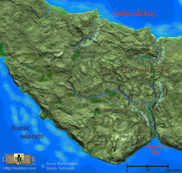
The Levasslar is the major river draining the Headlands region. Like many of the area's natural features, its name is derived from the dwarven language. Levasst, meaning "passage linking surface to underground", is a reference to the countless karstic openings into the underground along the cliffs and narrow gorges of the region from which water emerges to feed the river, and into which water sometimes disappears into the depths. The headwaters of the Levasslar is a region of very narrow, deep and twisty gorges where countless springs seem to erupt from the cliff faces. Local legend has it that in the ancient past many of the humanoids and other creatures native to the area sprang full formed from a primordial ooze issuing forth from the springs at the headwaters of the Levasslar, and spread across the Flanaess. Small boats and barges can navigate the Levasslar up to its junction with the Khanahllar, but frequent shallows and rapids make water travel very difficult beyond that by anything larger then a 6-man canoe. The Levasslar empties into the Azure Sea at Samryn Bay ("Samryn" meaning "trustworthy" or "favorable" in the dwarven language) where the City of Irongate lies.
The Khanahllar (Khanahl's River in dwarvish), is the largest tributary of the Levasslar. From its junction with the Levasslar, the Khanahllar reaches due north along a narrow valley into the center of the isthmus. Above the headwaters, a relatively flat, wide valley rises as a "hlar" (a gap or mountain pass), and continues over the drainage divide formed by the Baraktors (the "Backbone Hills"), and begins to descend downwards towards the north coast of the isthmus, meeting the valley of the Yaughlar. Sawsemis Khanahl was an ambitious, and some say delusional, explorer and dwarven entrepreneur, who lived in the area when humans first began to arrive in numbers to populate the settlement that would much later become known as the City of Irongate. Khanahl became obsessed with blazing a trade route between the burgeoning human-dwarf community on Samryn Bay and the coast of Dunhead Bay. So encompassing was his obsession that he even suggested moving the settlement inland so as to shorten the trade route, and dredging out the Levasslar and its northern tributary to allow larger ships to pass completely across the isthmus. While anyone with common sense knew that this was clearly impossible, Khanahl's friends and associates politely and amusingly humored him. The route become so closely associated with Khanahl's strange ideas that people began referring to the tributary as "Khanahl's River", and with time the original name of the stream became lost to history.
The Yaughlar ("Climbing River") flows east, then north, around the Yaughadartors ("the stepped hills"), emptying into a small bay on the coast of Dunhead Bay where the port of Northanchor lies. The Yaughlar is a relatively small river (in both length and outflow), and is not navigable by ships, however small barges can travel a few miles upriver up to a series of rapids at "The Narrows" where the Yaughlar passes through the Yaughadartors. The Yaughadartors are a series of stacked limestone escarpments sometimes referred to as "the Amphitheater of the Gods", each step a dizzying height unto itself, much like a complex tiered cake, each level of escarpment riddled with caves of both natural and unnatural origin. The headwaters of the Yaughlar emerge from several of these caves and tumble down the westernmost Yaughadartors in a series of spectacular waterfalls.
The Drachenslar, or "Dragon's River" is the most isolated river of the region. This fast torrent twists through deep, narrow gorges and is filled with impassable rapids. Dangerous creatures infest its entire length from coast to headwaters. Numerous legends tell of the presence of not only "mundane" monsters often encountered in the wild places of Oerth, but of mythical creatures as well. The most commonly whispered of these legends suggest that the inaccessible vertical-sided hills around these gorges are the last home of the original masters of the Dragonshead Peninsula... the dragons themselves. At the headwaters of the Drachenslar is an unexplored and impenetrable bog known as the Drachenslurmurk ("concealed waters of the Dragons"). Why this bog has formed in a region that, like most karstic landscapes, has excellent drainage, is unknown. Thus far, no explorer has been able to discover the secrets of the Drachenslurmurk and return to document it. Not far to the west of the headwaters of the Drachenslar is the second highest peak of the Headlands, the Drachenbarak (or "Dragon's Backbone"). A long and curved ridge, its jagged peak can barely be glimpsed in the distance between other peaks from the south and west along the Western Road, and from the few straight sections of the Drachenslar to the northeast. Legend says that the Drachenbarak is the throne of one of the most ancient dragons on Oerth. No one has tried to go calling.
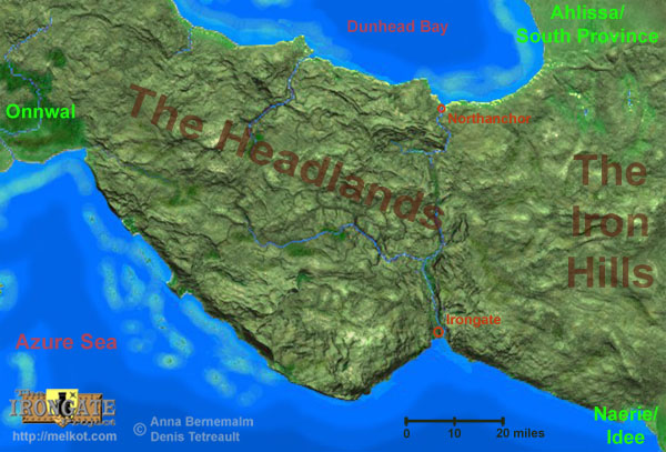
To the west of the city of Irongate lies the Arautor, or "the Great Hill", and represents the highest elevation in the isthmus. This massive highland is holy ground for the dwarves of the region, and is surrounded by many legends involving the origin of some of their gods, ancient forgotten temples, and lost dwarven cities. The Arautor highlands meet the Azure Sea with massive seacliffs that extend from Irongate, around the highlands and far beyond to the west, all the way to the plains of Onnwal. The southern coast of the Dragonshead Peninsula's isthmus is one of the most forbidding coastlines on Oerth, inaccessible by land, with small coves and numerous sea caves dotting the near-continuous cliffs. Monsters and pirates alike seek shelter here, and among the Kurst Islands off-shore, terrorizing any ships that dare sail within sight of the cliffs. Stories of hidden treasures and uncountable shipwrecks still lure the brave and foolish.
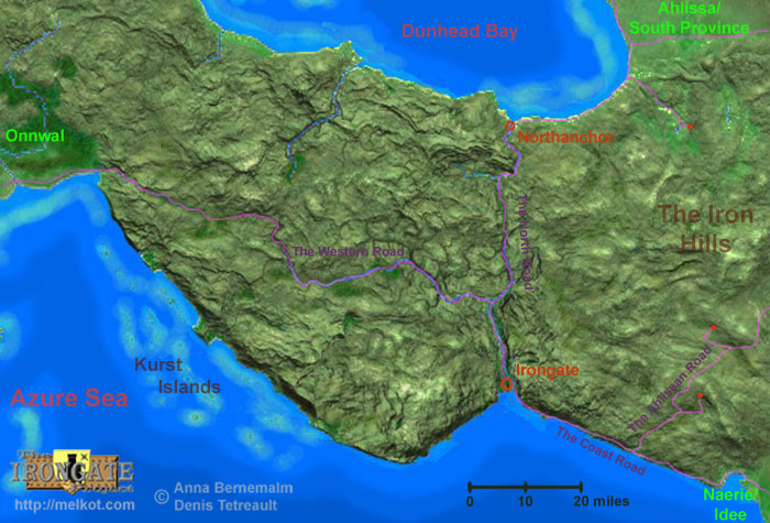 >
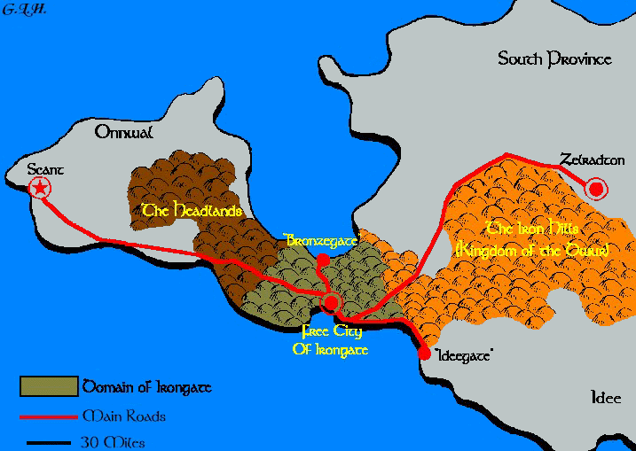
>The City of Irongate is the political and economic center for the region, and contains most of the local population. With a regional population of 71,000, the City of Irongate holds fully 51,400. The only other significant settlement is the small port-town of Northanchor with a population of approximately 4,850. Humans make up approximately 83% of the population, with the remainder consisting of dwarves (15%), halflings (1%), and other races (1%). The human population is mostly of oeridian descent, with some suel presence. The roads that connect Irongate to the surrounding territories are very few, and therefore very important. Irongate’s large and heavily fortified walls form a bottleneck to the flow of traffic between the southern provinces of the Great Kingdom and Onnwal. Its natural harbor is one of the few sheltered ports along the long coast stretching from Scant to Naerie, and it is typically the refuge of many scores of sea-going vessels at any given time.
The Coast Road, connecting Irongate with the dwarven enclaves in the
Iron Hills (by way of the Ahlissan Road, and other minor routes) and
the human Principality of Naerie (formally the nation of Idee, and now
a member of the United Kingdom of Ahlissa) is very
well traveled, and very important to the regional economy. Many small
coastal fishing communities dot the narrow strip of low land that
separates the Azure Sea from the Iron Hills.
Fish is very plentiful, and finds ready market in all three nations
(although much of the trade with Ahlissa/Naerie is unofficial, and
between individuals).
Very little farming occurs here as the steep edge of the rocky Iron
Hills highlands looms very close to the Azure shore. Any number of
coastline-related adventures can
be had here. Recently, a mysterious group of toughs have been selling
"protection" to the fisherman who are brave enough to fish the teeming
waters around the Kurst Islands. The Irongate government suspects that
they represent either a new group of brazen pirates, or shameless
con-men, but soon will likely send someone to investigate regardless.
The North Road crosses the 40-mile wide isthmus to the smaller port of Northanchor on the shores of Dunshead Bay and the Sea of Gearnat. Small farming communities as well as isolated farms dot the valley of the Levasslar along the North Road, particularly close to Irongate itself, becoming less and less common to the north up to the junction with Khanahllar. Beyond that point (along either tributary) very few individuals are brave enough to build permanent settlements, such are the dangers of the Headlands. While there is alot of fishing in and around Samryn Bay in the south and Dunhead Bay to the north, most non-seafood for the large city must be imported.Locally produced fresh food is in great demand, so any threats to these farms are taken very seriously.
Due to the incredible inaccessibility of the shoreline west of
Irongate, and the massive seacliffs that plunge directly into the Azure
Sea along most of its length, travel along the western coast is quite
impossible. The only land route to Onnwal is the Western Road,
a perilous and lonely trail along a series of
connected valleys that wind through the very heart of the wild
Headlands. Infested with humanoids and dangerous creatures, traders
normally travel in protective caravans, often hiring mercenaries and
experienced adventurers for protection. Encounters of a memorable kind
are quite frequent. Several groups of "guides" are organized into
competing organizations based in Irongate. Until very recently, most
traffic along the Western Road came to a virtual cessation after the
upheavals of the Wars. Lately, thanks to the stabilizing Onnwal
government, trade between Onnwal and Irongate along the road has begun
to trickle through with increasing frequency.
One group of interest is a clan of dwarves, descendents of Sawsemis
Khanahl, who operate a transport union of a type rather unusual for
dwarves
(and often are the subject of jokes by other dwarves). Khanahl's clan
operates an efficiently run portage system for the transportation of
goods between Irongate and Northanchor. Barges run goods up the
Levasslar to a fortified dock located where the Khanahllar joins the
Levasslar. Goods are then loaded onto carts or wagons and hauled along
the North Road up the Kanahllar valley, over the pass through the
Baraktors, and along the Yaughlar. Just north (down river) of the
Yaughlar's
"Narrows", the clan has another fortified dock where the goods are
loaded onto small barges and carried down river the last half dozen
miles to the port of Northanchor. While not the typical stone-working,
mining, or forge-working dwarven stereotype, the clan takes great pride
in its important work. The clan has a branch of warriors that serve as
guards along the sometimes dangerous route, though sometimes a
particularly tough problem moves into the area and the clan must hire
special assistance.
The Hobloggers of Irongate, a clan of halflings that specialize in logging
the tops of the rugged steep-sided hills in the region (see photo on the
Geology of Irongate page), have their guildhall
just to the northwest of the City of Irongate's northern Valley Gate. Most of
the easily reachable trees within the valleys have been removed for miles around
the city, so the services provided by the hobloggers are quite important. The
guild has developed specialized portable cable equipment for efficiently getting
large logs down the steep cliffs and onto the valley floor for transport to
the city. The wood is in much demand for construction, ship repairs, and, most
importantly, charcoal production to feed the forges of Irongate. Because of
the relative isolation of the hilltops with the best trees, the clan must sometimes
hire adventures to clear out the wildlife before they can bring in their cable
equipment to clear out the lumber. Two years ago one Hoblogger crew spotted
some particularly ancient trees on an isolated hill along the western Levasslar,
and climbed the precipitous cliffs. Only one of the would-be loggers returned,
and he was quite insane, mumbling incoherently about ancient pillars, statues
that came to life, and frightening tentacled undead.
Visit my active site map to see the entire website
at-a-glance, find out whats new, and instantly jump there with just a
click.
Return to the
main Irongate Project Page
Return to my
main
Greyhawk Page (in case you got here through a search engine)
